


st Canadet st Estève par le canal edf puis ROgnes

laurentnerual
User
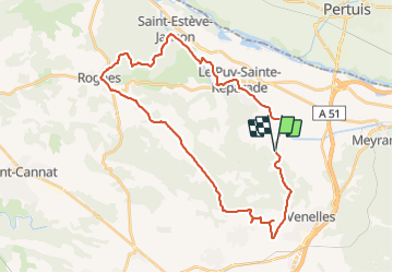

Length
37 km

Max alt
494 m

Uphill gradient
608 m
Km-Effort
45 km

Min alt
194 m

Downhill gradient
605 m
Boucle
Yes
Creation date :
2022-02-26 13:12:31.638
Updated on :
2022-02-26 16:07:16.85
2h54
Difficulty : Very difficult

FREE GPS app for hiking
 SityTrail
IGN / Geographical institutes
SityTrail Plus
The world is yours!
About
Trail Road bike of 37 km to be discovered at Provence-Alpes-Côte d'Azur, Bouches-du-Rhône, Le Puy-Sainte-Réparade. This trail is proposed by laurentnerual.
Description
retour par la route de Beaulieu et Couteron.
37 km de route
Positioning
Country:
France
Region :
Provence-Alpes-Côte d'Azur
Department/Province :
Bouches-du-Rhône
Municipality :
Le Puy-Sainte-Réparade
Location:
Unknown
Start:(Dec)
Start:(UTM)
698341 ; 4833721 (31T) N.
Comments